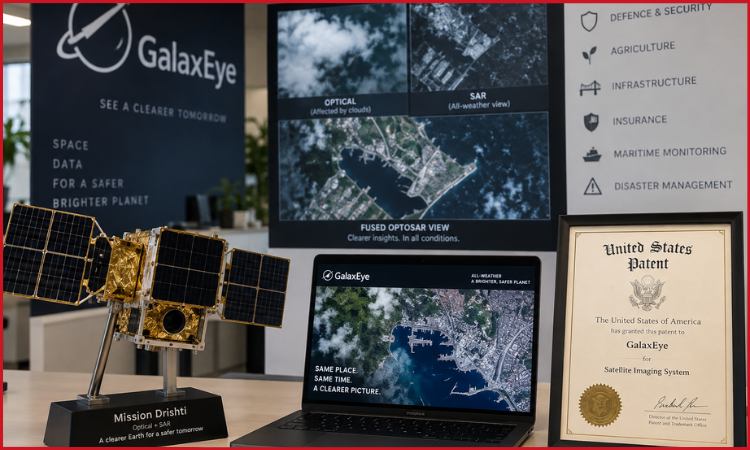
Indian space technology startup GalaxEye has secured a United States patent covering the core architecture behind its OptoSAR imaging system, strengthening the company’s intellectual-property position as it prepares to expand its Earth-observation satellite network.
The Bengaluru-based company’s technology synchronises optical and radar sensors so they can capture images of the same location at the same time and from the same satellite.
GalaxEye says it is the first Indian startup to receive a US patent specifically for satellite imaging technology. This is a company claim and has not been independently confirmed through a complete comparison of every satellite-imaging patent awarded to Indian businesses.
The underlying technology has already received patent protection in India. The new US patent gives GalaxEye additional protection in an important international market as it pursues customers across security, agriculture, infrastructure, insurance, maritime monitoring and disaster management.
OptoSAR Combines Two Types of Satellite Data
Conventional optical satellites capture images that are relatively easy for people and software systems to interpret. However, their performance can be limited by cloud cover, smoke and darkness because they depend on visible or infrared light reflected from the Earth’s surface.
Synthetic aperture radar, commonly known as SAR, sends microwave signals towards the ground and measures the signals that return. It can gather information during the day or at night and can operate through many weather conditions that obstruct optical cameras.
Organisations often combine optical and SAR images during analysis, but those images may have been captured by different satellites at different times and viewing angles. Changes can occur between the two passes, while differences in position can make precise alignment more difficult.
GalaxEye’s OptoSAR technology places optical and radar sensors on the same spacecraft and synchronises their operation. This allows the sensors to capture spatially and temporally matched information during a single pass.
The resulting dataset is intended to combine the visual clarity of an optical image with the all-weather capability of radar. For a disaster-response organisation, this could make it easier to assess a flooded or storm-affected area despite heavy cloud cover. Agricultural businesses could use the data to monitor crops, while insurers may employ it when assessing damage.
Defence, maritime and infrastructure users could also benefit from more consistent observations when environmental conditions prevent traditional optical imaging.
Chief executive Suyash Singh said the patented system would help GalaxEye provide weather-independent imaging services across international markets. Actual image quality and commercial performance will depend on factors including sensor resolution, satellite availability, processing speed and the frequency with which a location can be revisited.
Patent Supports a Planned Satellite Constellation
GalaxEye plans to deploy a 30-satellite constellation over the next five years. The company has not announced a complete launch schedule or disclosed the capital required to build and operate the full network.
A constellation can offer more frequent coverage than a single spacecraft because different satellites can pass over a location at shorter intervals. This becomes particularly useful for monitoring rapidly changing events such as floods, crop damage, shipping activity or construction projects.
GalaxEye launched its first satellite, Mission Drishti, on May 3, 2026, aboard a SpaceX Falcon 9 rocket from California. The satellite operates in a sun-synchronous low-Earth orbit and carries both a synthetic aperture radar sensor and a seven-band multispectral imager.
The company describes Mission Drishti as the first commercial satellite to place these two imaging systems together on one platform. GalaxEye’s published specifications list a fused image resolution of 1.8 metres, although the practical usefulness of the data will vary according to atmospheric conditions, processing and the application involved.
The company is also developing additional satellites with the aim of producing sharper imagery and reducing the time between observations. Its newly patented architecture could become particularly valuable if the same imaging arrangement is deployed consistently across the wider constellation.
GalaxEye has raised approximately $21 million in funding so far. Building 30 satellites will require it to manage manufacturing costs, launch availability, ground infrastructure and data-processing expenses while converting customer interest into recurring contracts.
A patent protects the invention from unauthorised commercial use in the country where it is granted, but it does not guarantee that the technology will generate revenue. GalaxEye will still need to demonstrate dependable satellite operations, useful image quality and competitive pricing.
StarOps Acquisition Adds Manufacturing Capabilities
In August, GalaxEye acquired Bengaluru-based spacecraft engineering company StarOps. The financial terms of the transaction were not disclosed.
StarOps brought experience in satellite platforms, propulsion, avionics, guidance, navigation, flight computing and mission operations. Its capabilities include satellite-bus platforms designed for spacecraft in the 50-kilogram, 150-kilogram and 250-kilogram categories.
The acquisition is intended to reduce GalaxEye’s dependence on outside suppliers by bringing more engineering and manufacturing work inside the company. Greater control over satellite design could help it shorten development cycles and maintain consistency as the planned constellation expands.
However, vertical integration also raises operating requirements. GalaxEye must fund specialised employees, testing equipment and production facilities before a larger satellite network begins generating income at scale.
The patent arrives as demand for commercial Earth-observation data continues to grow. Research firm SkyQuest Technology valued the global commercial satellite-imaging market at $6.55 billion in 2024 and projects it could reach $20.15 billion by 2033. That forecast represents an industry estimate rather than guaranteed market growth.
India is separately targeting a $44 billion commercial space economy by 2033 and has introduced policies intended to increase private participation in satellite manufacturing, launches and space-based services.
GalaxEye’s US patent gives the startup a stronger legal foundation for pursuing that opportunity internationally. Its next test will be operational: expanding beyond Mission Drishti, launching additional satellites and proving that synchronised optical and radar imagery can become a dependable commercial service.